Introduction
In the tech landscape, the fusion of GPS and dynamic geo-fencing marks a shift in spatial control. Unlike static versions, dynamic geo-fencing adapts virtual perimeters in real-time, offering responsiveness to changing conditions. Its significance lies in flexibility and precision, addressing limitations in traditional geo-fencing. This adaptability proves invaluable across sectors where real-time spatial management is crucial.
Purpose and Applications
Dynamic geo-fencing, beyond location tracking, serves as a tool for real-time spatial control. In fleet management, it ensures precise location data and adaptive boundaries, optimizing logistics. It enhances security by creating virtual barriers around assets, triggering immediate alerts. Applications span IoT, retail, offering pivotal tech for personalized experiences and optimized spatial operations in our interconnected world.
Dynamic Geo-Fencing Explained
Definition and Concept
Dynamic geo-fencing is a cutting-edge advancement in spatial control, representing a departure from traditional static geo-fencing. Unlike static boundaries that remain fixed, dynamic geo-fencing adapts in real-time to changing conditions, introducing a more responsive and intelligent approach to spatial management.
Static vs. Dynamic Geo-Fencing
Static geo-fencing relies on predefined, stationary boundaries. While effective in certain scenarios, it lacks the flexibility needed for dynamic environments. Dynamic geo-fencing, in contrast, adjusts boundaries based on real-time data. This adaptability is particularly crucial in scenarios where conditions fluctuate, ensuring that spatial parameters remain relevant and accurate.
For instance, consider a delivery vehicle using static geo-fencing around a warehouse. If the vehicle faces unexpected diversions, static geo-fencing may trigger false alerts. Dynamic geo-fencing, with its ability to adapt, offers a solution that aligns with the fluid nature of real-world situations.
Adaptive Boundaries
Adaptive boundaries are a key feature of dynamic geo-fencing. These boundaries evolve based on real-time contextual changes, allowing for a more nuanced and precise spatial control. Unlike static boundaries, adaptive ones respond to dynamic factors such as traffic variations, route changes, or external events.
In practical terms, imagine a delivery vehicle encountering delays. With adaptive boundaries, the geo-fence adjusts to accommodate the vehicle’s actual progress. This ensures that actions triggered by crossing the boundary are contextually accurate, providing a more intelligent and reliable spatial management system.
Dynamic geo-fencing’s adaptive boundaries make it an ideal solution for scenarios where spatial conditions are subject to change. Whether in logistics, security, or IoT applications, this technology offers a responsive and context-aware spatial management system, addressing the limitations of static geo-fencing.
Use Cases and Industries
Transportation and Logistics
Dynamic geo-fencing is a game-changer in transportation and logistics. For fleet management, it provides real-time location tracking and adaptive boundaries, optimizing routes and adjusting to unexpected delays. This ensures efficient operations, timely deliveries, and resource optimization.
IoT and Smart Cities
In IoT and smart cities, dynamic geo-fencing enhances the intelligence of urban environments. Connected devices with GPS use dynamic geo-fencing to improve functionality. For example, smart streetlights adjust illumination based on real-time occupancy within dynamically defined areas. In smart cities, this technology optimizes resource usage, contributing to sustainable and efficient urban spaces.
GPS Integration in Dynamic Geo-Fencing
Role of GPS in Geo-Fencing
Real-time Location Tracking
The integration of GPS in dynamic geo-fencing is instrumental for real-time location tracking. GPS technology enables precise and continuous monitoring of the device’s location, allowing dynamic geo-fencing to adapt boundaries based on the current position. This real-time tracking is crucial in scenarios where the spatial context is constantly changing, such as in fleet management or asset tracking.
Geo-fence Triggering Mechanisms
GPS technology serves as the backbone for geo-fence triggering mechanisms. When a device equipped with GPS crosses predefined boundaries, the system is instantly alerted. This instantaneous response is critical for applications like security or logistics, where timely reactions to boundary crossings are essential. GPS ensures the accuracy and reliability of these triggering mechanisms, providing a robust foundation for dynamic geo-fencing.
Challenges and Solutions
Signal Interference
A significant challenge in GPS integration for dynamic geo-fencing is signal interference. Buildings, tunnels, or dense urban environments can impede GPS signals, leading to inaccuracies in location tracking. To address this, advanced algorithms and technologies, such as multi-sensor fusion, are employed. These techniques combine GPS data with other sensor inputs to mitigate signal interference and enhance the accuracy of location tracking in challenging environments.
Power Consumption Considerations
Power consumption is a critical consideration, especially in mobile devices that rely on GPS for dynamic geo-fencing. Continuous GPS usage can drain device batteries quickly. To mitigate this, power-efficient GPS modules and optimization strategies are implemented. Additionally, technologies like geofencing APIs and low-power modes are utilized to strike a balance between accurate tracking and efficient power management, ensuring prolonged device operation without compromising performance.
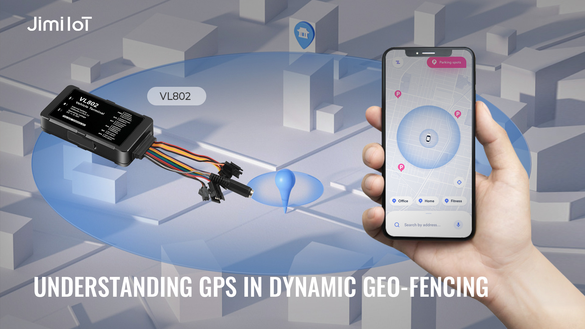
VL802 4G GPS Tracker
Features and Specifications
The VL802 4G GPS Tracker by JimiIoT offers essential features for dynamic geo-fencing. With 4G connectivity, high-precision GPS tracking, and a compact design, it ensures reliable and accurate performance. Real-time tracking, geofencing capabilities, and a durable build make it suitable for various applications.
Integration with Dynamic Geo-Fencing
The VL802 seamlessly integrates with dynamic geo-fencing systems, allowing real-time adjustments to virtual perimeters. Its GPS capabilities play a central role in defining accurate boundaries, providing businesses with a versatile tool for spatial control, especially in logistics, security, and fleet management.
The VL802 excels in real-world scenarios, offering tangible benefits across various applications. In fleet management, the real-time tracking feature optimizes routes, reducing fuel consumption and enhancing operational efficiency. For security applications, geofencing capabilities ensure prompt alerts and responses to boundary breaches. The VL802’s robust design adds an extra layer of reliability, making it a trusted solution for businesses implementing dynamic geo-fencing strategies.
Geo-Fencing Functionality
Specifically designed for geo-fencing applications, the VL802 offers robust functionality in defining and managing virtual perimeters. Users can easily set up and modify geo-fences in real-time, allowing for adaptive spatial control. Whether it’s creating geofences around delivery routes or securing a specific area, the VL802’s geo-fencing features provide a user-friendly and efficient solution for businesses seeking to enhance their spatial control strategies.
Applications
In real-world scenarios, the VL802 delivers tangible benefits, especially in fleet management. The real-time tracking feature optimizes routes, leading to reduced fuel consumption and improved operational efficiency. In security applications, the geofencing capabilities ensure immediate alerts and responses to any breaches of predefined boundaries. The robust design of the VL802 adds an extra layer of reliability, making it a trusted and effective solution for businesses implementing dynamic geo-fencing strategies tailored to their specific needs.
About JimiIoT
Jimi IoT is a global leader in innovative IoT solutions. We provide cutting-edge hardware and software tailored to enhance efficiency and connectivity. Our range of products includes advanced GPS tracking devices, asset management solutions, smart vehicle dashcams, and telematics platforms. With a focus on technological excellence and customer satisfaction, we empower businesses to optimize operations and gain valuable insights from data-driven analytics. Trust JimiIoT to drive positive change and unlock growth opportunities in the digital age.
If you would like more details, please visit Facebook, LinkedIn, INS, and Twitter pages to learn more.