Signal Obstructions
Urban canyons, characterized by towering skyscrapers and closely packed structures, significantly impact the performance of GPS signals. The tall buildings act as obstacles, blocking direct line-of-sight between GPS satellites and receivers. This obstruction leads to signal degradation and, in some cases, complete signal loss. As a result, GPS devices may struggle to establish and maintain a stable connection in these densely built environments.
Multipath Interference
In urban canyons, another challenge arises in the form of multipath interference. This occurs when GPS signals bounce off reflective surfaces such as glass facades or metal structures, creating multiple signal paths. The GPS receiver then receives both the direct signal and the reflected signals, leading to confusion and inaccuracies in determining the device’s actual location. Multipath interference is a common phenomenon in areas where signal reflections are abundant, exacerbating the complexities of urban navigation.
GPS Signal Weakness
The weakness of GPS signals in urban areas is influenced by various factors. The tall buildings not only obstruct signals but also contribute to signal weakening. Additionally, atmospheric conditions, such as rain or fog, can further attenuate GPS signals, making them less reliable.
Inertial Navigation Systems (INS) Overview
Basic Principles of INS
Inertial Navigation Systems (INS) represent a cutting-edge technology that enables precise navigation without relying on external signals. The fundamental principle of INS lies in the laws of motion physics. Unlike GPS, which depends on signals from satellites, INS utilizes internal sensors to constantly monitor and calculate the vehicle’s position, velocity, and orientation.
At its core, INS employs accelerometers and gyroscopes to measure changes in velocity and angular rate. Accelerometers track alterations in speed along the three axes, providing insights into acceleration and deceleration. Simultaneously, gyroscopes detect changes in angular rate, indicating the vehicle’s rotation in three dimensions. The integration of these sensor measurements over time results in a continuous and accurate estimation of the vehicle’s movement, forming the foundation of inertial navigation.
INS vs. GPS
Comparing INS with GPS reveals distinct advantages, especially in challenging environments. While GPS relies on signals from satellites, it can face limitations in urban canyons, tunnels, or areas with signal obstructions. INS, on the other hand, operates independently of external signals, making it highly reliable in situations where GPS might falter.
In challenging scenarios like urban environments, INS excels in providing continuous and accurate navigation. It doesn’t rely on line-of-sight with satellites, making it particularly effective in situations where GPS signals are weak or unavailable. The discussion on INS versus GPS sets the stage for exploring the practical applications of inertial navigation in addressing urban navigation challenges.
Mitigating GPS Challenges with INS
Real-time Compensation for Signal Loss
In the intricate web of urban canyons, GPS signals often face interruptions due to towering structures. Inertial Navigation Systems (INS) act as a real-time compensator, seamlessly taking the reins when GPS signals are lost. The system’s internal sensors, namely accelerometers and gyroscopes, work together to track the vehicle’s movements continuously. This real-time compensation ensures uninterrupted navigation, providing a reliable solution in areas prone to GPS signal loss.
Overcoming Multipath Interference
Multipath interference, a common woe in urban canyons, results from signal reflections off buildings, leading to inaccuracies in GPS tracking. INS plays a crucial role in mitigating this interference. By relying on its internal sensors rather than external signals, INS remains unaffected by reflections and ensures the accuracy of position, velocity, and orientation data. This capability makes it a robust solution for navigating complex urban landscapes with signal reflection challenges.
Addressing GPS Signal Weakness
Urban environments often exhibit weak GPS signals due to various factors. INS, with its self-contained navigation capabilities, acts as a resilient ally in these scenarios. Whether navigating through areas with dense foliage, tunnels, or other signal-challenged zones, INS maintains accuracy without relying on strong GPS signals. This addresses one of the fundamental challenges posed by weak GPS signals in urban settings, making navigation more dependable and precise.
The seamless integration of INS into the navigation framework not only compensates for GPS challenges but elevates the overall accuracy and reliability of vehicle positioning, especially in environments where traditional GPS systems face limitations.
Applications of INS in Urban Environments
Navigation for Autonomous Vehicles
In the realm of autonomous vehicles, Inertial Navigation Systems (INS) play a crucial role in simplifying navigation. Unlike traditional GPS systems that can falter in urban canyons or areas with poor satellite visibility, INS offers a reliable alternative. By leveraging its internal sensors, including accelerometers and gyroscopes, INS provides continuous and precise data on the vehicle’s position, speed, and orientation. This aids autonomous vehicles in navigating seamlessly through complex urban environments, ensuring safety and accuracy in their journeys.
Urban Delivery Logistics
In the dynamic landscape of urban delivery logistics, INS emerges as a valuable tool for optimizing delivery routes. The intricate web of city streets, varying traffic conditions, and the need for efficient delivery timelines make accurate navigation paramount. INS, with its ability to maintain precise positioning even in areas with GPS signal challenges, contributes to route optimization. By integrating INS into delivery systems, logistics companies can enhance the efficiency of their operations, reduce delivery times, and navigate urban landscapes with greater precision.
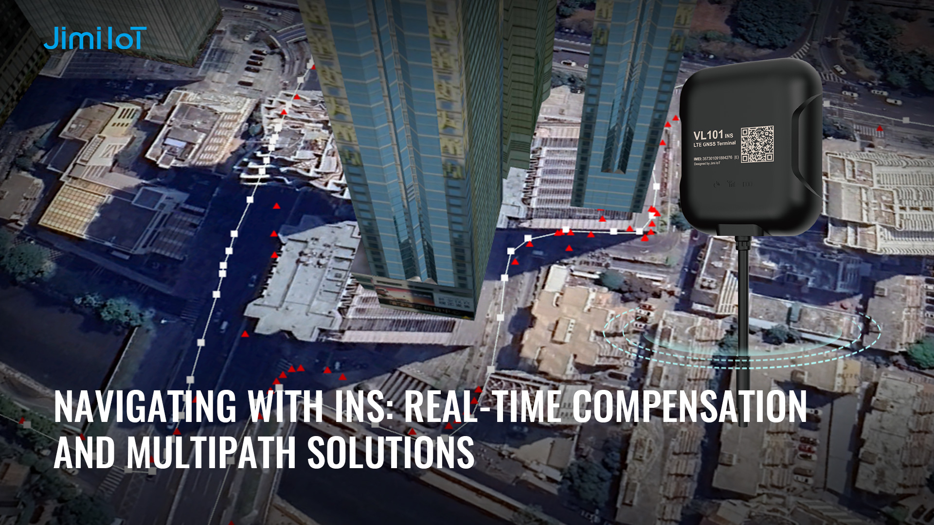
Hardware Integration: JimiIoT VL101G
The VL101G is a 4G vehicle tracker with GNSS positioning technology and dual-frequency GPS, ideal for a wide range of deployments where real-time location and accurate positioning are key. LTE communication with GSM (2G) fallback ensures a solid connection in almost all cases, and the inertial navigation system (INS) provides accurate information about your car’s movements even in areas with weak GPS signals. Moreover, driving behavior analysis, ignition detection and remote engine cut-off will make the VL101G a valuable part of your fleet management strategy.
INS-Aided GPS Tracking
The standout feature of the VL101G lies in its Inertial Navigation System (INS) functionality, which significantly enhances GPS tracking. When faced with challenges like signal obstructions in urban canyons or weak satellite signals, the INS takes charge, ensuring continuous and accurate positioning. This capability is particularly crucial for applications demanding precision in dynamic and complex urban environments.
Comprehensive Positioning Technologies
Equipped with GPS, BDS, GLONASS, and Galileo positioning systems, the VL101G ensures a robust and reliable satellite connection. The inclusion of Dual-Frequency GPS further enhances the accuracy of positioning data, providing users with confidence in the device’s performance.
Versatile Applications
The VL101G caters to a wide range of applications, from fleet management to vehicle rental services. Its usage-based insurance capabilities make it a valuable asset for insurance providers seeking accurate and real-time data on driving behavior. The device’s adaptability to diverse scenarios is a testament to its effectiveness in addressing the evolving needs of modern industries.
Enhanced Features for Operational Control
Beyond its navigation prowess, the VL101G offers features like remote cut-off for fuel and power, ensuring enhanced security and operational control. The device’s IP66 dust and water resistance further solidify its durability, making it suitable for challenging environmental conditions.
Insightful Driving Behavior Analysis
Understanding driver behavior is integral to improving overall fleet management and road safety. The VL101G excels in this aspect by providing driving behavior analysis, offering insights into acceleration patterns, deceleration tendencies, and turn efficiency.
Seamless Integration with TTL Interface
The TTL interface of the VL101G ensures seamless integration with various systems, allowing for easy implementation into existing setups. This flexibility enhances the device’s utility across different industries, making it a versatile choice for businesses seeking reliable and advanced vehicle tracking solutions.
the JimiIoT VL101G stands as a comprehensive GNSS Vehicle Terminal with advanced INS capabilities, making it a standout choice for industries where precise and uninterrupted navigation is paramount.
About Jimiiot
JimiIoT is a global leader in innovative IoT solutions. We provide cutting-edge hardware and software tailored to enhance efficiency and connectivity. Our range of products includes advanced GPS tracking devices, asset management solutions, smart vehicle dashcams, and telematics platforms. With a focus on technological excellence and customer satisfaction, we empower businesses to optimize operations and gain valuable insights from data-driven analytics. Trust JimiIoT to drive positive change and unlock growth opportunities in the digital age.